Thursday, October 4, 2018

Greyhawk Underdark Updated

It's been quite a while since I posted my updates to, at that time FtF campaign, delve into the Underdark. My online Roll20 campaign is now half way through the Giants series, and so it was time to re-visit those maps.
I had originally re-done Denis' Encyclopedia Subterranica maps at that time, but I'm still not completely 100% happy with it. Since the original module is already in the old-school blue, and the other scans I have of the Underdark maps from the various Into the Depths modules aren't quite high enough resolution for the online game, I did the next best thing. Now any normal/sane person would have just fired up their scanner and used any of the many modules he owns of this product to get a better, higher resolution image, but noooo, not this guy. Fired up the imaging software instead and went in and redid the map in a closer adaptation of the original maps found in the published works. Don't get me wrong, I liked the others maps out there, just had to make one I was satisfied with.


Here are the results from that little side trip into OCD-land. While it's doubtful the time spent resulted in any great contribution to this already overdone [and some cases better done] map, it nevertheless made me happy about the results achieved. Now to get on with the all the battlemaps for all those many encounters listed on the map. [heavy sigh]


Edit; Since things can always be tweaked now that there is a template to work from, changed out the b&w for colored passages on the map.


Since I already had the hand drawn maps from the Trading Grounds done went ahead and did that first. These are only for my personal online game on Roll20 and meant as an example of my hack job at putting together maps.


This from the original below

Tuesday, August 21, 2018

Byzantine Empire Illustrations


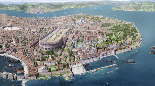
A great deal of the Byzantine Empire of the mid-15th century lives on in the work of the French illustrator Antoine Helbert. You can see some of Helbert's work on his site, which is divided into two sections: one for scenes of Byzantium, and one for the architecture of Byzantium. The latter category, images from which you see here, includes such world-famous landmarks as Hagia Sophia, Boukoleon Palace, and the Great Palace of Constantinople — the city now known as Istanbul, Turkey.


Friday, June 29, 2018

Medieval Trade Routes

From Martin Jan Månsson, a graduate student in Spatial Planning at the Blekinge Institute of Technology, Sweden. Not studying cartography nor history, Månsson has produced this very detailed map of trading routes during the Middle Ages. (You can download the map in high resolution here.)

I can only assume that instead of working on his dissertation he found this to be much more fascinating. Can't really say I blame him.

“I think trade routes and topography explains world history in the most concise way,” Månsson explains in the very small print at the map’s lower right corner. “By simply studying the map, one can understand why some areas were especially important--and remained successful even up to modern times.”

The map covers some 200 years, spanning both 11th and 12th centuries, and “depicts the main trading arteries of the high Middle Ages, just after the decline of the Vikings and before the rise of the Mongols, the Hansa and well before the Portuguese rounded the Cape of Good Hope.”

It also shows the complex routes already available to Africa and Asia, and the areas where Muslim and Christian traders would meet. The open-to-trade Song Dynasty ruled China, and the competitive kingdoms in the Indonesia region provided both Muslims and Europeans with spice.

Looking like a railway map, Månsson’s work shows how interconnected we really were back in the Middle Ages, from Greenland in the west to Kikai and Kagoshima in the East, from Arkhangelsk in the frozen north to Sofala in modern-day Mozambique.

Månsson credits Wikipedia for a majority of the basic work, but also lists 20 other sources for this detailed work, including The Silk Road by Valerie Hanson, Across Africa and Arabia by Irene M. Franck and David M. Brownstone.

Harlan Ellison


Say what you will about the man, his stories were inspired/inspiring. Probably this intro by Asimov from Dangerous Visions best encapsulates some of the salient points about Ellison, besides its kinda funny.


Monday, June 25, 2018

Wednesday, May 30, 2018

Caverns of Thracia

Its seems like forever since the last post. Which is kinda true. Haven't had the inclination to post anything for a while now. The FtF game has switched over to Swords & Wizardry and we're currently going through B2 Keep on the Borderlands and have just started The Caverns of Thracia. The Keep has been covered previously in this blog, so we'll look at the Caverns of Thracia instead. Since the group is still in the midst of this adventure I won't post too much but thought to cover some of the basics.
The Caverns of Thracia is considered by many to be a classic old school adventure from none other than Paul/Jennell Jaquays. While this might be true the actual maps in the adventure are somewhat confusing. This has been documented in various places and is not something new that is being pointed out. A good clarification of some of the interconnections of the maps can be found here.

I have the original module from back in the days of the Compleat Strategist in Montclair. While going over the adventure in preparation of running this I found the need to revise/update the maps to have a better grasp of the various interconnected levels/rooms/passages. While I do this as a matter of routine when starting any new adventure this proved to be more than just my passing need to re-do the maps in old school blue in this case. You can see some of the areas explored thus far by the group on the map in blue.


Compare this to the original;


Not that radical of a difference but the DM version has some more detail/info than what's shown in the published version. At least the old/original that I have. From what I'm given to understand the maps have been re-done and are much clearer these days in the newer version for sale. The first level map has been posted in more than a few places, so I'm not really giving anything away here. 


A good level 1 treatment of the map/adventure can be found here if anyone's interested.


Wednesday, February 14, 2018

National Parks in the Style of Tolkien's Middle Earth Maps

Two things that go great together, for me at least, are maps and Tolkien. That seems to be the case for Dan Bell, an English artist who maps his homeland's national parks in an artistic style similar to the one in which Tolkien rendered Middle-Earth.
 visit his site.
 visit his site.

He works from open source maps, adding in such additional details, not always found in most national parks, as forests, Hobbit holes, towers, and castles. He's adapted the national parks of the United Kingdom as well as places like Oxford, London, Yellowstone National Park, and George R.R. Martin’s Westeros.

Just a disclaimer since he sells these maps, I'm not associated with him in any way.


Tuesday, February 6, 2018

City of Greyhawk [available again]


Granted its 2e, but still  good to be back. 
From the description:
Available now in print on demand formats:
The City of Greyhawk (2e)

From the high towers of its grand universities to the rancid alleys of its darkest slums, the City of Greyhawk awaits you. Center of magic and learning in the Flanaess, Greyhawk is also the home of powerful thieves, mighty warriors, traitorous ambassadors, and honest craftsmen.
They all await you within the pages of this information-packed boxed set.

You get four full-size, full-color maps, each depicting a different aspect of the Greyhawk campaign. Two 96-page books give you a detailed overview of the city and a closer look at its more influential citizens - and its more notorious criminals.

Monday, February 5, 2018

& Magazine #14 - Animal Companions

Download Magazine
This issue features:
Included in this issue include feature articles:
Animal Amalgamations
Animal Companions …
Dogs of the Lakelands

Bonus articles:
Political Treasures in D&D
Ability Checks: Are You Doing It Wrong?
Making the ‘God Call’

and Regular Columns:
Town Maps: Library and Records Hall
Gilderlo Hippogriffs
Who Let The Dogs Out?
A Plethora of Ideas
New Weapons VIII – Siege Weaponry
Brewmaster: Extraordinary Holy Symbols

Wednesday, January 24, 2018

Largest Early Map of the World [Monte's 10 ft. Planisphere of 1587]

We in the early 21st century can call up detailed maps of almost any place on Earth with little more effort than typing its name. Most of us can dimly recall a time when it wasn't quite so easy, but imagine trying to satisfy your geographical curiosity in not just decades but centuries past. For the 16th-century Milanese gentleman scholar Urbano Monte, figuring out what the whole world looked like turned into an enormous project, in terms of both effort and sheer size. In 1587, he created his "planisphere" map as a 60-page manuscript, and only now have researchers assembled it into a single piece, ten feet square, the largest known early map of the world.

Monte made his map to serve not only as a geographical tool but also to show climate, customs, length of day, distances within regions - in other words, to create a universal scientific planisphere. In his dedication on Tavola XL he specifies how to arrange the sheets of the planisphere and makes it explicit that the whole map was to be stuck on a wooden panel 5 and a half brachia square (about ten feet) so that it could be revolved around a central pivot or pin through the north pole. This was never done, but now we can do it virtually - Monte's 60 sheet world map digitally assembled into a 10 foot planisphere:


The 10 Foot Diameter Planisphere Digitally Assembled from Monte's 60 Sheet Gores with Additional Sheets for the Corners

You can see/download Monte's planisphere in detail at the David Rumsey Map Collection, both as a collection of individual pages and as a fully assembled world map. There you can also read, in PDF form, cartographic historian Dr. Katherine Parker's "A Mind at Work: Urbano Monte's 60-Sheet Manuscript World Map." And to bring this marvel of 16th-century cartography around to a connection with a marvel of 21st-century cartography, they've also taken Monte's planisphere and made it into a three-dimensional model in Google Earth, a mapping tool that Monte could scarcely have imagined — even though, as a close look at his work reveals, he certainly didn't lack imagination.

Ursula K. Le Guin

“For a word to be spoken, there must be silence. Before, and after.”